Ihre BestellungSie haben soeben einen Artikel in den Warenkorb gelegt. Ihnen stehen nun die folgenden Möglichkeiten zur Verfügung:
|
|
Artikelbeschreibung
HOLY LAND - JANSSON, Johannes - HORNIUS, Georgius. gefunden im Sachgebiet: Karten und Pläne 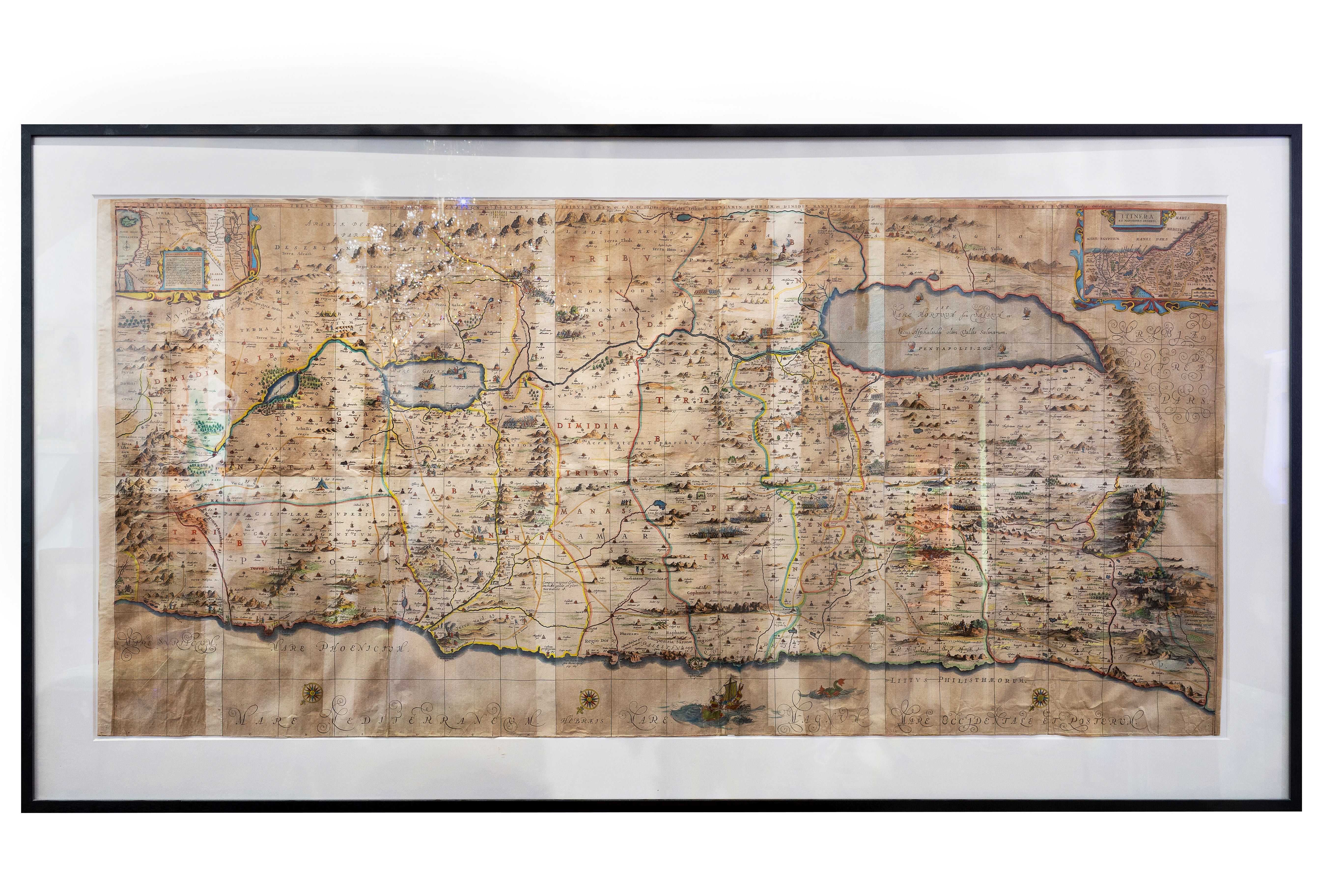
Orig.-copperplate engraved map, hand coloured (in old colours). Height: 91,4 cm. (36 in); Width: 185, 4 cm. (73 in).
Eine der seltensten und schönsten Palästina-Karten. In sechs Teile geteilt nach Osten gerichtet zeigt sie das gesamte Gebiet Israels, den Golan, Libanon. Zahlreiche Darstellungen nach biblischen Szenen, Berge und Wälder in Profildarstellungen verlebendigen den Eindruck. - An extraordinary map, this is the 1662 Johannes Jansson and Georgius Hornius six part map of the Holy Land. Divided into six panels and oriented to the East, this map covers Israel of the Holy Land from the southern tip of the Dead Sea and Edom to the Golan Heights and modern day Lebanon. This map is an expansion and enlargement of a smaller plan of the samen general area issued by Christian van Adricham around 1590. Jansson expanded and embellished Adricham`s map in order to illustrate the text composed by Georgius Hornius (George Horn) for volume six of His `Novus Atlas, Accuratissima Orbis Antiqui Delineatio`. Consequently some refer to this map, which is as a whole untitled, as the `Hornius Map.` As a whole this map embellished with countless vignettes and other images drawn from Biblical tradition. The smoking ruisn of Sodom and Gomorra appear in the Dead Sea, Jonas is drawn being devoured by the whale, there is a mountain on which Jesus arguing with Satan, etc. Each of the tribes of Israel are named and associated with their lands. Mountains and forest are shown in profile. [SW: Karten und Pläne, Palästina] Karten, Pläne, Palästina
EUR8.000,00
inkl. MwSt. zzgl. Versand: Auf Anfrage
Dieses Angebot wurde bereits 97 mal aufgerufen
Ihre zuletzt aufgerufenen Angebote
Sparen Sie Versandkosten beim Kauf ähnlicher Angebote dieses Anbieters
FF-Nutzer: Kostenloses Such-Plugin für Antikbuch24 installieren Sie sind auf der Suche nach einem anderen Titel?Oder durchsuchen Sie unsere Seite doch einmal mit Google! |
Antiquariat Burgverlag, AT-1010 Wien 
Antiquariat Alfred Tauchnitz Wortgefechte … Knochenfunde … Genomics … Dachschaden … Ulenspiegel … Anakonda … Kanada … Annuals … Trebulino … Herbstreise
· Vorderasien [1397] vom 05.11.2018 · Griechenland [1396] vom 05.11.2018 · Lebensberater [1395] vom 05.11.2018 · Kakteen und Zimmerpflanzen [1394] vom 04.11.2018 · Allgemeine Geographie [1392] vom 25.10.2018 7.808.463 Angebote 106.085.216 Besucher gesamt (seit 15.08.2005) 0 Besucher heute 0 Besucher gestern |